Vilas, Colorado
The town of Vilas is a statutory town located in Baca County, Colorado, United States. The population was 98 at the 2020 census.[5]
Town of Vilas | |
|---|---|
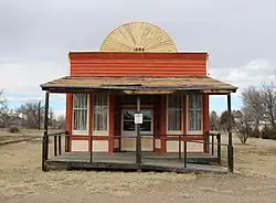 A former saloon on Main Street. | |
 Location of Vilas in Baca County, Colorado. | |
| Coordinates: 37°22′27″N 102°26′49″W | |
| Country | |
| State | |
| County[1] | Baca County |
| Incorporated | June 25, 1888[2] |
| Government | |
| • Type | Statutory Town[1] |
| Area | |
| • Total | 0.13 sq mi (0.33 km2) |
| • Land | 0.13 sq mi (0.33 km2) |
| • Water | 0.00 sq mi (0.00 km2) |
| Elevation | 4,154 ft (1,266 m) |
| Population | |
| • Total | 98 |
| • Density | 750/sq mi (300/km2) |
| Time zone | UTC-7 (Mountain (MST)) |
| • Summer (DST) | UTC-6 (MDT) |
| ZIP code[6] | 81087 (PO Box) |
| Area code | 719 |
| FIPS code | 08-81030 |
| GNIS feature ID | 0203869 |
A post office called Vilas has been in operation since 1887.[7] The community was named after William Freeman Vilas, a United States Senator from Wisconsin.[8]
Geography
Vilas is located in east-central Baca County at 37°22′27″N 102°26′49″W (37.374134, -102.446928).[9] U.S. Route 160 passes just to the north of the town, leading west 11 miles (18 km) to Springfield, the county seat, and east 9 miles (14 km) to Walsh.
According to the United States Census Bureau, the town has a total area of 0.1 square miles (0.26 km2), all of it land.
Demographics
| Census | Pop. | Note | %± |
|---|---|---|---|
| 1940 | 129 | — | |
| 1950 | 132 | 2.3% | |
| 1960 | 107 | −18.9% | |
| 1970 | 83 | −22.4% | |
| 1980 | 118 | 42.2% | |
| 1990 | 105 | −11.0% | |
| 2000 | 110 | 4.8% | |
| 2010 | 114 | 3.6% | |
| 2020 | 98 | −14.0% | |
| U.S. Decennial Census | |||
See also
References
- "Active Colorado Municipalities". State of Colorado, Department of Local Affairs. Archived from the original on 2009-12-12. Retrieved 2007-09-01.
- "Colorado Municipal Incorporations". State of Colorado, Department of Personnel & Administration, Colorado State Archives. 2004-12-01. Archived from the original on 2010-12-02. Retrieved 2007-09-02.
- "2019 U.S. Gazetteer Files". United States Census Bureau. Retrieved July 1, 2020.
- "US Board on Geographic Names". United States Geological Survey. 2007-10-25. Retrieved 2008-01-31.
- United States Census Bureau. "Vilas town; Colorado". Retrieved April 28, 2023.
- "ZIP Code Lookup". United States Postal Service. Archived from the original (JavaScript/HTML) on 2010-11-22. Retrieved 2008-01-07.
- "Post offices". Jim Forte Postal History. Retrieved 11 July 2016.
- Dawson, John Frank. Place names in Colorado: why 700 communities were so named, 150 of Spanish or Indian origin. Denver, CO: The J. Frank Dawson Publishing Co. p. 50.
- "US Gazetteer files: 2010, 2000, and 1990". United States Census Bureau. 2011-02-12. Retrieved 2011-04-23.
External links
Wikimedia Commons has media related to Vilas, Colorado.
Municipalities and communities of Baca County, Colorado, United States | ||
|---|---|---|
| Towns |  Map of Colorado highlighting Baca County | |
| Unincorporated communities | ||
This article is issued from Wikipedia. The text is licensed under Creative Commons - Attribution - Sharealike. Additional terms may apply for the media files.