Pettingell Peak
Pettingell Peak is a 13,559-foot (4,133 m) mountain summit on the Continental Divide in the Front Range of the U.S. State of Colorado. Pettingell Peak straddles the Divide between Roosevelt National Forest in Clear Creek County and Arapaho National Forest in Grand County. Pettingell Peak is the highest point in Grand County, Colorado. The peak is located 8.3 miles (13.4 km) southwest of Berthoud Pass.
| Pettingell Peak | |
|---|---|
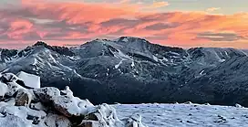 Southeast aspect, centered at top | |
| Highest point | |
| Elevation | 13,559 ft (4,133 m)[1] NAVD88 |
| Prominence | 1,563 ft (476 m)[1] |
| Isolation | 4.39 mi (7.07 km) to Mount Parnassus[1] |
| Listing | |
| Coordinates | 39.7286355°N 105.9046172°W[2] |
| Geography | |
 Pettingell Peak | |
| Location | Continental Divide, High point of Grand County |
| Country | United States |
| State | Colorado |
| Counties | Clear Creek County and Grand County |
| National Forests | Arapaho National Forest and Roosevelt National Forest |
| Parent range | Front Range of the Southern Rocky Mountains |
| Topo map | USGS 7.5' topographic map Loveland Pass, Colorado[2] |
Mountain
Pettingell Peak is a popular hiking and skiing destination due to its proximity to the Denver Metropolitan Area.
See also
- Colorado
- Geography of Colorado
- List of mountain peaks of Colorado
- Category:Mountains of Colorado
- List of mountain peaks of Colorado
- Geography of Colorado
References
- "Pettingell Peak, Colorado". Peakbagger.com. Retrieved June 29, 2022.
- "Pettingell Peak". Geographic Names Information System. United States Geological Survey, United States Department of the Interior. Retrieved June 29, 2022.
External links
- Colorado state government website
- Pettingell Peak at 14ers.com
- Pettingell Peak at alltrails.com
- Pettingell Peak at climb13ers.com
- Pettingell Peak at elevationoutdoors.com
- Pettingell Peak at exploringtherockies.com
- Pettingell Peak at mountainouswords.com
- Pettingell Peak at peakvisor.com
- Pettingell Peak at summitpost.org
- Pettingell Peak at trailforks.com
This article is issued from Wikipedia. The text is licensed under Creative Commons - Attribution - Sharealike. Additional terms may apply for the media files.