Mount Chamah
Mount Chamah is located in the Titiwangsa Mountain Range in northwestern Gua Musang District of Kelantan, Malaysia, close to the border with Perak. It is the fifth highest mountain in the Malay Peninsula and is one of the peninsula's few mountains above 2,172 metres (7,126 ft).[1] It is the second highest point in the state of Kelantan.
| Mount Chamah | |
|---|---|
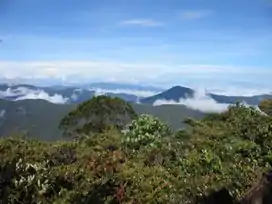 Sunrise on the summit | |
| Highest point | |
| Elevation | 2,172 m (7,126 ft)[1] |
| Prominence | 1,041 m (3,415 ft) |
| Listing | Ribu |
| Coordinates | 5°13′43.34″N 101°34′24.41″E |
| Naming | |
| Native name | Gunung Chamah (Malay) |
| Geography | |
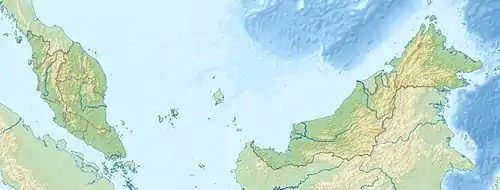 Mount Chamah Location in Malaysia | |
| Location | Gua Musang District, Kelantan |
| Parent range | Titiwangsa Mountains |
| Climbing | |
| Easiest route | Rekom Trail (east) |
During the period of the Communist Insurgency, this area was out of bounds for ordinary citizens. However, after the peace agreement between the Malaysian government and the communists that was signed in Hat Yai in the 1980s, the authorities began to relax their rules on jungle trekking in the Titiwangsa Range.[2]
Mount Chamah is considered to be a challenging mountain to climb due to its limited access points. The area is mostly unexplored and home to a population of Malayan tigers.
See also
References
- Malayan Nature Society (2001). Malaysian Naturalist. Malaysian Nature Society. p. 14. Retrieved 2022-11-01.
- Boon Kheng, Cheah (2009). "The Communist Insurgency in Malaysia, 1948-90: Contesting the Nation-State and Social Change". New Zealand Journal of Asian Studies.